



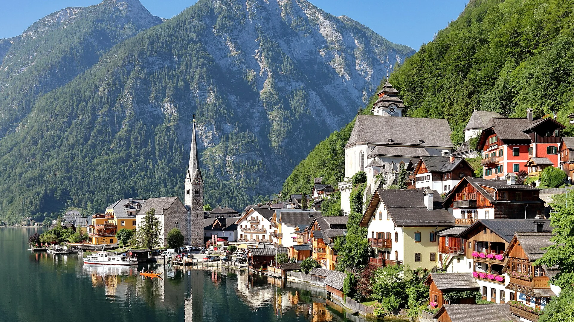





















Stepping off the morning ferry onto the cobblestones of Hallstatt often feels like walking straight into a promotional postcard that has come uncomfortably to life. Tour groups pack the shoreline promenade of Seestraße, selfie sticks obscure the 16th-century wooden gables, and the clatter of roll-aboard luggage echoes off the sheer rock faces of the Salzkammergut. Most visitors stay less than three hours, replicate the classic postcard frame from the northern viewpoint, buy a wooden magnet, and leave.
They miss the point entirely. Hallstatt is not a museum set—it is an ancient, living mining settlement pinned between dark waters and the limestone crags of the Dachstein massif. By ditching the main street and pushing into the high-elevation paths, you transition instantly from a tourist logjam into silence, ancient spruce forests, and dramatic geological formations. If you want to experience the true spirit of classic Austria alpine villages, you must climb.
This field guide uncovers the best Hallstatt secret viewpoints, pristine Hallstatt hiking trails, and the cultural context required to explore this UNESCO World Heritage region with genuine depth and solitude.
Quick Travel Snapshot
- Best Time to Visit: Mid-May to late June, or late September to October (avoid July–August day-tripper surges).
- Nearest Major Airport: Salzburg Airport (SZG), approximately 80 km (1 hour 20 minutes by car).
- Recommended Duration: 2 to 3 days to hike the higher elevations and explore the Echerntal Valley.
- Entrance Fees: Village access is free; Salt Mine funicular & tour costs €40+; Dachstein Krippenstein cable car starts around €45.
- Trail Difficulty: Moderate to Demanding (elevation rises violently from the lake shore).
Escaping the Waterfront: Hallstatt Secret Viewpoints
While hundreds of tourists queue on the northern wooden boardwalk near Gosaumühlstraße to capture the postcard angle, you can find vastly superior perspectives simply by gaining 100 to 400 meters of vertical altitude.
Lake Level (508m) -> Beinhaus Terrace (540m) -> Soleweg (650m) -> Rudolfsturm (855m) -> Plassen Peak (1,953m)The Upper Trail Behind the Catholic Charnel House
Instead of lingering at lake level, take the narrow stone staircases cutting upward from the marketplace toward the Pfarrkirche Mariä Himmelfahrt (Assumption of Mary Catholic Parish Church). Most visitors look at the painted skulls inside the Beinhaus (Charnel House) and immediately turn around.
Continue past the churchyard gate along the elevated cemetery path. Looking south through the cemetery’s hand-wrought iron crosses, you get an uninterrupted, elevated frame of the lake’s dark northern reaches and the iconic Gothic church spire without a single tourist’s umbrella in your shot. Morning light hits this side of the village with crisp clarity, illuminating the wooden shingles before the midday haze sets in.
The Historic Mule Track (Soleweg Path)
Long before modern roads pierced the rock, miners walked brine uphill and downhill along the Soleweg—one of the oldest functioning industrial pipeline routes in the world.
To reach it without taking the commercial funicular, locate the trailhead near the Hallstatt Lahn bus station. The trail climbs sharply through beech woods via numbered switchbacks. At roughly 200 meters above the lake, you emerge onto a bench terrace that overhangs the village roofs. Looking down, the ferry looks like a miniature scale model slicing through glacial water. You are close enough to hear the church bells ring across the water, yet far enough to escape the drone of street-level chatter.
The Rudolfsturm Balcony Ridge
The Rudolfsturm is an ancient defense tower built in the late 13th century to protect the salt mines from rival archbishops. While modern tourists ride the Salzbergbahn funicular directly to the glass-floored Skywalk platform, knowledgeable hikers bypass the metal viewing bridge and traverse the wooded ridge extending north from the tower.
Following the trail toward the ancient burial grounds (Gräberfeld), small dirt footpaths veer off through mountain pine toward natural rock ledges. These outcroppings look down over the sheer southern drop into the fjord-like waters below. The view easily rivals the dramatic cliff-hugging vistas found in our Amalfi Coast Trails guide, yet it remains distinctly Austrian with its crisp alpine breeze and mist-shrouded limestone peaks.
Top Hallstatt Hiking Trails: High Alpine Escapes
The mountains surrounding the lake offer some of the most dramatic elevation profiles in Upper Austria. Leave the village behind for a few hours to discover a quiet mountain wilderness.
       [ Plassen Summit: 1,953 m ]
                 /
      [ Rudolfsturm: 855 m ]
              /
   [ Echerntal Valley: 580 m ]
           /
[ Hallstätter See: 508 m ]
1. The Echerntal Valley & Glacier Garden Loop
- Distance: 7.5 km round-trip
- Elevation Gain: 320 m
- Duration: 2.5 to 3 hours
- Difficulty: Easy to Moderate
The Echerntal trail branches southwest from the village, leading directly into a glacial basin carved during the last Ice Age. Nineteenth-century romantic painters like Ferdinand Georg Waldmüller walked this trail to study pure alpine light, and remarkably few tourists venture this way today.
The path follows the rushing Waldbach stream past traditional timber homes before entering deep forest. Your first major stop is the Gletschergarten (Glacier Garden), an open-air geological display of massive potholes and swirling rock depressions carved by meltwater torrents 12,000 years ago. Suspended wooden bridges allow you to peer straight down into deep churn holes where crystalline water roars through smooth limestone basins.
2. Waldbachstrub Waterfall Circuit
Continuing up from the Glacier Garden, the trail climbs toward the Waldbachstrub. Here, three separate mountain torrents merge and plunge 90 meters over sheer limestone cliffs into a dark canyon pool.
The spray keeps the surrounding gorge perpetually cool and moss-covered, even in the middle of summer. An interpretive historical trail outlines how lumberjacks engineered timber slides (Holzriesen) along these cliffs to feed the roaring fires of the Hallstatt salt pans. The hike requires sturdy trail shoes with dependable traction, as damp limestone can be slick.
3. The Ascent of Mount Plassen (1,953 m)
- Distance: 13 km round-trip
- Elevation Gain: 1,445 m
- Duration: 6 to 7 hours
- Difficulty: Strenuous
If you are a seasoned trekker looking for complete solitude, the Plassen is the ultimate alpine objective directly above Hallstatt. Unlike popular summits in the Dolomites Travel Guide, the Plassen receives only a handful of hikers per day.
Starting from the Salzberg high valley behind the salt mines, trail 640 cuts aggressively through mountain meadows before turning into a rocky scramble along the summit ridge. The final 30 minutes require sure-footedness across exposed limestone scree. At the summit cross, you are rewarded with a panoramic 360-degree vista: the Dachstein Glacier glitters to the south, the Gosau valley unfolds to the west, and the entire Hallstätter See lies thousands of feet below your boots.
Cultural Depth: The 7,000-Year Salt Legacy
Hallstatt is not an artificial scenic stop—it gave its name to an entire era of European prehistory: the Hallstatt Culture (800–450 BC). Long before the Romans marched over the Alps or royal palaces like Neuschwanstein Castle were envisioned, prehistoric people were extracting rock salt here by torchlight.
Deep inside the Salzberg, wooden stairs dating to 1344 BC have been preserved by the hyper-saline environment, making them the oldest preserved timber stairs in Europe. For thousands of years, brine was collected and boiled down using massive wood-fueled pan complexes. Salt brought immense wealth, funding the Renaissance gabled houses, the ornate church altars, and the defensive fortifications that hold up the village today.
When you hike through the high alpine valley behind the village, remember that the ground beneath your feet is hollowed out by over 65 kilometers of historic tunnels and mine workings.
Comprehensive Practical Logistics
TRAIN ROUTE TO HALLSTATT:
Vienna / Salzburg -> Attnang-Puchheim -> Hallstatt Bahnhaltestelle -> Stefanie Ferry -> Village Center
Public Transit
- By Train: Take the ÖBB train to the Hallstatt Bahnhaltestelle station. This station sits across the lake with no road access. Step off the train and board the historic passenger ferry Stefanie, which syncs with all train arrivals and carries you across the lake to the village market dock (€3.50 one way, cash only). This approach offers the best introductory view of the village.
- By Bus: Bus 542 from Bad Ischl connects via Gosaumühle directly to the Hallstatt Lahn bus terminal on the southern edge of town.
Driving & Parking Coordinates
Avoid driving into the village center—it is pedestrianized, strictly monitored by license-plate recognition cameras, and fines exceed €100 for unauthorized entry.
- Parkplatz P1 (South): Located near the tunnel entrance. Features electronic displays indicating open bays. Best for day hikers.
- Parkplatz P2 (Salzbergbahn): Best if you intend to visit the salt mines early.
- Cost: Expect to pay between €4.50 and €6.00 per hour, with 24-hour maximums around €30 to €45. Arrive before 8:30 AM to secure a bay, or park at Obertraun across the lake and take the scenic public foot ferry.
Alpine Fare: Where to Eat Away from the Crowds
Avoid the self-service burger windows along Seestraße. Traditional Salzkammergut cuisine focuses on fresh alpine lake fish, rich dairy, and slow-braised mountain meats.
- Steegwirt (Bad Goisern): Located just north of the lake along the Traun River. A historic tavern awarded for its modern takes on traditional Austrian cooking. Order the fresh Hallstätter See Reinanke (lake whitefish), pan-fried simply with brown butter and parsley potatoes.
- Gasthof Simony Courtyard: Tucked behind the Marktplatz inside a 15th-century townhouse. Sit in the quiet garden terrace bordering the water for an afternoon slice of Topfenstrudel (curd cheese strudel) paired with an Einspänner coffee.
- Rudolfsturm Restaurant: While the Skywalk platform outside is loud, grab an outside corner table on the historic defense tower terrace for a warm bowl of Kasnocken (egg noodles tossed in pungent mountain cheese and topped with crispy fried onions).
Sustainable & Respectful Travel in Hallstatt
Because Hallstatt accommodates up to one million visitors annually within a footprint designed for 780 residents, responsible behavior is paramount:
- Honor Drone Prohibitions: Drones are strictly banned across the entire municipality and nature reserve without special civil aviation permits. Fines are substantial and strictly enforced by local authorities.
- Respect Residential Privacy: Private wooden steps and boathouses are frequently marked with Privat signs. Never open closed garden gates or peer into low ground-floor windows.
- Pack Out All Trash: High-elevation trails have no trash collection. Carry a waste bag in your daypack and dispose of waste at the valley collection points.
- Maintain Quiet Hours: The acoustics of the lake basin amplify sound across the water. Keep voices down early in the morning and past 8:00 PM.
Frequently Asked Questions
Can you visit Hallstatt on a day trip without getting caught in the crowds?
Yes, if you invert the standard day-tripper itinerary. Arrive by 7:30 AM via early train or park before the morning buses arrive. Spend the early hours walking through the village and along the church cemeteries. By 10:00 AM, climb into the Echerntal Valley or ascend the Soleweg hiking trails. Return to the village center after 4:30 PM, when day-tour coaches depart and quiet settles over the lake.
What is the best hiking trail in Hallstatt for intermediate hikers?
The Waldbachstrub Waterfall and Glacier Garden Loop in the Echerntal Valley is the premier intermediate choice. It offers roughly 300 meters of gradual climbing over well-graded gravel paths, showcasing glacial pools, historical timber-driving infrastructure, and waterfall cascades without requiring technical scrambling equipment.
Are drones allowed in Hallstatt for aerial landscape photography?
No. The entire municipal area of Hallstatt, including the lake surface and surrounding protected nature reserves, is an enforced no-fly zone for recreational drones. Police routinely issue on-the-spot fines for unauthorized flights.
How does Hallstatt compare to other Austria alpine villages?
Hallstatt is visually unique because of its sheer vertical backdrop; homes sit on timber piles driven directly into the lakebed beneath sheer rock faces. However, neighboring Salzkammergut villages like Altaussee, Grundlsee, and Saint Wolfgang offer similar mountain architecture with far fewer tourists. If you prefer high alpine peaks and mountaineering hubs, explore our guide to Zermatt & Matterhorn for higher-altitude trekking alternatives.